Satellite Imagery Insights: SkyFi’s $12.7M Bet
Satellite Imagery Insights: Why SkyFi’s Series A Matters
Satellite images used to feel like something only governments, defense contractors, or massive hedge funds could access easily. For everyone else, it was expensive, slow, and confusing.
Now, that’s changing fast.
As reported by TechCrunch [LINK TO SOURCE], Austin-based startup SkyFi just raised $12.7 million to make satellite imagery easier to access—and more importantly, easier to understand. And that second part matters most.
Because in 2026, the real competitive advantage isn’t getting a satellite photo. It’s getting an answer.
Key Facts (Quick Summary)
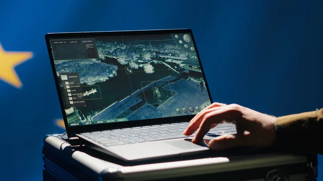
SkyFi is building a marketplace-style platform for satellite and geospatial imagery. Think of it like a “search-and-buy” experience for satellite data—except with analytics layered on top.
Here’s what was announced:
-
SkyFi raised $12.7M in Series A funding
-
The company partners with 50+ geospatial imagery providers
-
Users can access imagery through a website and mobile app
-
SkyFi supports satellite tasking, meaning customers can request images of a location at a specific time
-
The round was co-led by Buoyant Ventures and IronGate Capital Advisors
-
SkyFi serves industries like finance, defense, infrastructure, and insurance
CEO Luke Fischer described the company’s direction simply: “Imagery is a commodity… it’s not just about speed of delivery, but… speed of delivery of answers.”
Why Satellite Imagery Insights Are Suddenly a Big Deal
The world is drowning in data—but starving for decisions.
Satellite imagery is a perfect example. There are thousands of satellites orbiting Earth, and more are launching every year. Many can capture high-quality images frequently, sometimes close to real time.
So the bottleneck isn’t “can we get an image?” anymore.
The bottleneck is:
-
Can we find the right image fast?
-
Can we trust it?
-
Can we turn it into something actionable?
-
Can we do it without a team of GIS specialists?
This is where satellite imagery insights becomes the real product—not the pixels.
SkyFi’s approach signals a broader shift happening across tech: platforms that win aren’t just aggregators. They become interpreters.
The Bigger Trend: From Raw Imagery to “Answer-as-a-Service”
SkyFi is tapping into a major trend that’s reshaping industries: customers don’t want tools—they want outcomes.
In the same way businesses moved from buying servers to buying cloud computing, we’re seeing a move from:
Buying satellite imagery → Buying geospatial intelligence
That’s a big difference.
A satellite image alone might show a construction site. But an insight might answer:
-
Is construction activity accelerating or slowing down?
-
Did the project stop for weeks?
-
How does it compare to last quarter?
-
Is there risk exposure in the supply chain?
For finance teams, that’s decision fuel.
For insurers, it’s risk modeling.
For governments, it’s monitoring and response.
For infrastructure operators, it’s planning and verification.
In other words: insights compress time. And time is money.
What Makes SkyFi’s Model Interesting (and Hard to Copy)
Plenty of companies can sell access to data.
But SkyFi has two advantages that are tough to replicate quickly:
1) A growing supply network
SkyFi says onboarding new imagery providers is now basically “table stakes.” That suggests the platform has momentum and credibility with partners.
More providers also means more sensor types and coverage options—so customers can get the imagery that actually fits their use case.
2) A feedback loop powered by demand
SkyFi’s CEO pointed out something subtle but powerful: the company sees what customers ask for again and again.
That matters because it helps them productize insights customers already want, instead of guessing.
It’s similar to how consumer apps improve through usage patterns—except here, it’s enterprise-grade geospatial demand shaping the roadmap.
Practical Implications: What Happens Next
This funding round isn’t just a win for SkyFi. It’s a signal of where the market is heading.
Here are the most likely next steps we’ll see:
-
More self-serve geospatial analytics
Tools will get easier for non-technical teams. Expect “click-button insights” instead of heavy GIS workflows. -
Faster satellite tasking for time-sensitive events
“Tasking satellites on demand” will become a standard expectation—especially for emergencies, inspections, and fast-moving operational needs. -
More defense + commercial overlap
The investor mix (including dual-use and defense-focused firms) shows that geospatial tech is becoming a shared foundation across public and private sectors. -
Imagery becomes cheaper, insights become premium
If imagery becomes commoditized, platforms will compete on:-
interpretation
-
reliability
-
speed
-
workflow integration
-
What Readers Can Do With This (Even If You’re Not in Space Tech)
You don’t need to work in aerospace to learn from this story.
If you’re building a product, leading growth, or managing operations, here are a few takeaways worth stealing:
-
Don’t sell data—sell decisions.
Customers pay more for clarity than complexity. -
Build for accessibility.
SkyFi’s mobile-first approach matters because it widens the market dramatically. -
Watch where investors are moving.
The rise in defense-related investment suggests resilience in “real-world” infrastructure tech. -
Turn requests into product strategy.
The fastest product roadmap often comes from repeated customer questions.
Conclusion: Satellite Imagery Insights Are Becoming the New Standard
SkyFi’s $12.7M raise is more than a funding headline—it’s a marker of how quickly the geospatial industry is evolving.
The future won’t belong to whoever has the most satellite images.
It’ll belong to whoever delivers the best satellite imagery insights—the kind that help people act faster, reduce risk, and make smarter decisions without needing a specialized team.
And if SkyFi keeps turning imagery into answers, they’ll be in a strong position as this market moves from niche to necessary.
Q: What does SkyFi do?
A: SkyFi is a geospatial platform that helps users access satellite imagery from dozens of providers and turn it into actionable insights. Instead of hunting through multiple vendors, customers can search, purchase, and even task satellites through a single interface.
Q: What does “tasking a satellite” mean?
A: Tasking a satellite means requesting that a satellite capture a new image of a specific location at a specific time. This is useful when you need updated visuals for inspections, risk events, construction progress, or fast-changing situations.
Q: Why is satellite imagery becoming more valuable now?
A: Satellite imagery is more valuable because access is improving and image frequency is increasing. But the biggest shift is that businesses want insights, not raw images. Platforms that add analytics help teams make faster decisions with less manual analysis.
Q: Who uses satellite imagery insights the most?
A: Industries like finance, defense, insurance, and infrastructure benefit heavily because they rely on real-world visibility. Satellite imagery insights can help monitor assets, assess risk, track activity, and validate changes in remote or high-impact locations.
Q: Will satellite imagery become a commodity?
A: Yes, it’s trending that way. As more satellites launch, basic imagery access becomes less exclusive. The premium value shifts to interpretation—meaning analytics, alerts, workflows, and decision-ready insights become what customers pay for.